V-Alert for NAMFS: A Weather Reporting & Property Monitoring Tool (Powered by Earthvisionz)
“Location intelligence isn’t optional — it’s the difference between reacting to a storm and being ahead of it.”
Overview
Weather and its impact on assets in the mortgage field services industry is a daily concern. From storms and floods to wildfires and high-wind events, unexpected weather events can disrupt operations, increase costs, and put properties at risk.
To help members stay ahead, NAMFS partners with Earthvisionz to deliver V-Alert — a weather tracking and property-monitoring tool tailored for the field services industry. The tool helps you grow revenues and control costs by delivering critical location intelligence when you need it.
What is V-Alert?
- V-Alert integrates vast data streams (FEMA, NOAA, NWS, InciWeb and more) to monitor 130+ alert types across weather and disaster events.
- The platform maps your asset or property inventories and aligns them with alert boundaries — enabling you to see threats relative to your locations.
- For NAMFS members, the version via NAMFS includes email notifications for events within 50 miles of your business ZIP code, helping you stay aware of nearby risks and respond proactively.
Key Features & Benefits
- Email Alerts for Local Events — Receive notifications when weather- or disaster-related events occur near your business region or service zones, allowing you to mobilize resources early.
- Live Map & Asset Visualization — Navigate a heat-map style interface that shows real-time alerts, threat intensity, and affected zones.
- Simple Asset Upload & Tagging — Upload your properties, tag them with key attributes (occupancy, roof type, value, etc.), and let the system link alerts directly to the assets you care about.
- Risk Prioritization — View alerts by type (hail, flood, wind, wildfire, etc.), severity, and proximity to assets. Prioritize inspection or preservation tasks based on real-time data.
- Cost Efficiency & Revenue Growth — With early warning and asset intelligence, you can reduce emergency dispatches, minimize damage losses, and promote value-added services to your clients.
Why It Matters
- Operational Readiness: Know when a severe weather event is headed toward key properties, so you can schedule inspections, boarding, winterization, or other responses ahead of time.
- Reduced Risk & Cost: Being proactive lowers claim exposures, reduces drill-work, and helps you capture and bill more effectively for urgency-driven services.
- Competitive Advantage: Ability to offer weather-aware service differentiates your firm and adds value to client relationships.
- Data-Driven Decision Making: Use location-based intelligence as part of your service matrix — from bidding to mobilization to reporting.
How It Works
- Sign Up as a Member — Access V-Alert via the NAMFS member portal.
- Upload Your Asset List — Add service zones, ZIP codes, or specific property portfolios.
- Define Alert Parameters — Set alert radius (50 miles or more), choose alert types (hail, flood, wind, etc.), and decide how you’ll be notified (email, etc.).
- Receive Alerts & Act — When V-Alert detects an event that meets your criteria, you receive an alert. Map view shows your assets within that event boundary.
- Prioritize Response — Use the alert to guide inspection scheduling, vendor deployment, preservation actions, or client notifications.
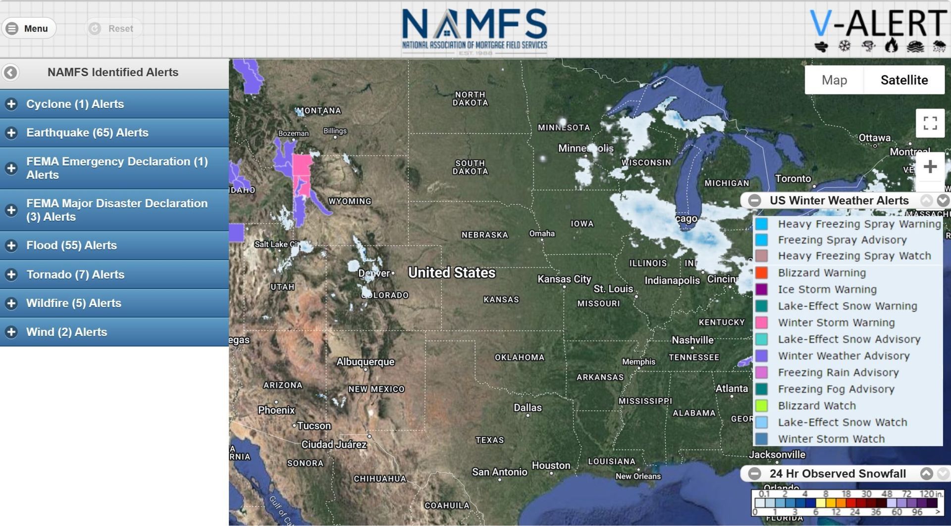
Image & Screenshot Insight
The screenshot below shows how the V-Alert map interface displays NAMFS-identified alerts with heat-map visualizations across U.S. regions (hail, wind, flood, etc.). The left panel lists alert types and counts, showing how many events are active under each category. This visualization enables rapid situational awareness for service providers.